Answers to Activity Corner–3 (Chapters 8 to 10)
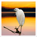
A. Solve the riddle given below. Paste the picture of the animal mentioned in the riddle in
the box.
I live in water but I am not a fish,
I give birth to babies,
and do not have gills.
Who am I?
I am _S_ H _A_ _R_ _K_.
C. In the table given below, mark the simple machines on which the given pictures are
based. One has been done for you.
Simple machine
Lever Science
Pulley
Inclined plane
Screw
Wedge
Wheel and axle
201
11
Science YYContent: some interesting facts about planets given in the textbook.
Explain that each planet in the Solar system is unique and
• Warm-up has some distinct characteristics. Help the students learn the
names of the planets in correct order using an acronym like:
• The Solar System
• Earth’s natural satellite – the Moon MY VERY EASY METHOD JUST SET UP EIGHT PLANETS
• Movements of the Earth
First letter of each word represents the name of the planets
YYLearning Objectives: in order. Encourage students to come up with more such
acronyms of their own.
To enable students to:
• understand the overview of Solar system and its Now ask the following questions:
• What makes Earth a unique planet in the Solar system?
planets • Which is the largest planet in the Solar system?
• learn about Moon and its characteristics • Which is the smallest planet in the Solar system?
• understand movements of the Earth and its key terms • Which planet is closest to the Sun?
• Which planet is farthest from the Sun?
YYMethodology:
Now, ask the students to complete the ‘Try it out’ exercise.
Objective 1: To understand the overview of Solar
system and its planets Conduct the following activity to make students learn about
planets in detail.
Activity 1.1: Understanding key terms related to Solar
system: Start the session by asking the students if Earth is Activity: Trip to Planets
a star or a planet or a satellite. Explain that a star is a hot 1. Divide the class in eight groups. Tell them that they are
ball of glowing gases, a planet revolves around the star, and
a satellite is a smaller heavenly body which revolves around the tour guides.
the planet. Once they understand the three terms clearly, ask 2. Give each group a planet to sell. Tell them that they have
them to do the ‘warm-up’ activity.
to research about unique features of the planet which
Read the topic ‘The Solar System’ from the textbook. Ask the they can sell to the class.
students to answer the following so that they are clear about 3. Let each group prepare a one page brochure about their
the different terms used in relation to Solar system. planet.
• Name three main bodies which make up the Solar 4. Tell the groups to make their presentations in front of the
class talking about their planets.
system. 5. Let the class vote for the ‘best tour operator.’
• Which of these have light of their own—stars, planets,
Activity 1.3: Building a model of Solar system: Help the
satellites? students build a model of Solar system.
• Who revolves around whom? Make two combinations
What you need:
from given words: • Large shoe box
• Black paint or paper
Sun, Planets, Satellites • White marker
• Different colour paints – orange, yellow, red, blue,
Now, explain that all planets revolve around the Sun on their
fixed path called orbit. They are held together along with green, silver and gold
their satellites through gravity. • Glue
• Balls of different sizes
Activity 1.2: Understanding planets in the Solar system: Start • Sticky tape or glue
the session by asking the students to recall the names of the • Needle and thread
eight planets of the Solar system. Tell the students that Earth
is a unique planet in the Solar system as it is the only known
planet to have life on it. Tell them the reason for this. Read
202
What you do: Give the above sheet to the students to record the shape of Science
1. Paint the inside of a shoe box with black paint and mark the Moon every day, for a month.
white dots with a marker. Objective 3: To understand movements of the Earth
2. Now, sort the balls according to the relative sizes of the and its key terms
planets. Activity 3.1: Understanding rotation of the Earth: Explain
3. Paint the balls with different coloured paints, i.e., orange and that Earth not only goes around the Sun but spins around
itself (on an imaginary axis) too. This movement of the Earth
yellow for Sun, green and blue for Earth, red for Mars, etc. around itself is called rotation. Rotation of the Earth causes
4. Thread the balls and pin them in the shoe box according day and night.
to the correct position of the planets from the Sun. Ask the students to conduct the following activity in pairs to
5. You can help the students to add extra effects, like adding understand the rotation of the Earth.
a ring to Saturn. Activity: What causes day and night
Objective 2: To learn about Moon and its characteristics What you need:
Activity 2.1: Understanding characteristics of Moon: Explain • A plastic ball
that Moon is a satellite which revolves around the Earth. • A cut-out of the map of your country
Show the following picture and ask the students to complete • An adhesive
the sentences given below it. • A torch
Moon What you do:
Sun Earth 1. Take a plastic ball. Also take a cut-out of the map of your
1. is the centre of Solar system. country. Paste the cut-out of the map at an appropriate
2. revolves around the Sun. place on the ball. (You can take help of the globe to do
3. revolves around the Earth. so.)
Activity 2.2: Understanding phases of the Moon: Explain 2. Let one student hold and slowly rotate the ball. The other
that Moon seems to change shape every night. Moon does student should stand and shine a torch on the ball.
not have light of its own. It gets light from the Sun. Depending 3. If the country you live in is on say, that half of the ball
upon what portion of it is lit by the Sun, we see that part of on which the torchlight is shining, then it is day there
the Moon. because it is facing the Sun.
4. Turn the ball from left to right. As you turn the ball, your
country will move from the light half to the dark half.
Time to watch the Sun go down. Keep going through the
night.
5. When the map comes around again, it’s time to wake up.
There went one whole day!
6. Notice that the Sun did not move. It is the spinning of the
Earth that causes day and night!
Moon Tracker
Sun Mon Tue Wed Thurs Fri Sat
Now, ask the students to complete the ‘Try it out’ exercise.
Activity 3.2: Understanding revolution of the Earth
The students already know that the Earth moves around
the Sun in a fixed orbit. This movement of Earth is called
revolution. Tell the students that the Earth’s axis is not
completely straight, it is slightly tilted. The tilt of the Earth’s
axis and revolution of the Earth around the Sun causes
change in seasons on the Earth.
203
Start the session by asking the following questions: YYUsage of technology:
• What are the different types of seasons we have in You can recapitulate the chapter by showing the following
India? Does it get too hot or too cold sometimes? video in the class.
• What are the seasons in other parts of the world? Are https://www.youtube.com/watch?v=sJrDiUG2JAo
they same as in India?
Class work: Ask the students to complete questions A, C, and
• Do you know some places on Earth always have ‘night’ E in the class.
or darkness for some days during winters?
Homework: Give students questions B, D and F to do as
Ask the students to look at the diagram shown below and homework.
notice how the Sun’s light is falling on different parts of the
Earth as it revolves around the Sun.
Spring Winter
Sun Winter solstice
Summer solstice
Summer Autumn
Earth
Science
204
Answers to Questions of textbook
Put a tick () against the correct statements.
1. Our Sun is a star.
2. Stars have their own heat and light.
3. A constellation is a group of stars seen in the sky.
4. There are nine planets in the solar system.
5. Moon is the nearest neighbour of Earth in space.
Page 5 1J Try it out
2V E N U S
Science
P
3S A T E L L I T E
T
E
4S A T U R N
U
N
Page 7
a. Rotation b. Atmosphere c. Satellite d. Saturn e. Revolution
EXERCISES
A. 1. c 2. b 3. a 4. c 5. b
B. 1. Moon 2. sun 3. summer season 4. Planets 5. Mars, red
C. 1. T 2. F 3. F 4. F 5. T
D. 1Ðc 2Ðe 3Ðb 4Ða 5Ðd
E. 1. Jupiter and Saturn (Answer may vary) 2. Mercury 3. Telescope
4. Sun 5. No
205
Science F. 1. The shape of the moon that we see from the Earth depends on how much of it is lit up by
the Sun.
2. Some smaller heavenly bodies move around the planets too. These are called their satellites.
Saturn.
3. While revolving around the Sun, if, the Northen Hemisphere of the Earth is tilted towards the
Sun then the Southern Hemisphere is tilted away from it. This is the reason they experience
different seasons at the same time.
4. In rotation, earth spins around on its axis while in revolution, earth revolves around the sun.
5. The revolution of Earth around the Sun causes change of seasons on the Earth. The Earth
experiences a cycle of four seasons every yearÑsummer, autumn, winter and spring. The Earth
is tilted on its axis at an angle of about 23.5°. While revolving around the Sun, if, the Northen
Hemisphere of the Earth is tilted towards the Sun then the Southern Hemisphere is tilted away
from it. This tilt of the Earth will result in the rays of the Sun falling vertically over the Northen
Hemisphere. Hence, this hemisphere will experience summer season. At the same time, the
Southern Hemisphere will experience winter season. After six months, the situation reverses.
Subject Link
365 times
206
12
Answers to Questions of textbook
Match the following.
1Ðd 2Ðb 3Ða 4Ðc
Try it out
Page 18
c. Water vapour cools and condenses on the glass as it is a cold winter morning.
Page 20
a. Chlorine b. Filtration c. Sedimentation
EXERCISES Science
A. 1. b 2. c 3. a 4. c 5. c
B. 1. sun 2. Underground 3. surface 4. faster 5. land
C. 1. F 2. F 3. T 4. T 5. T
D. 1Ðc 2Ðe 3Ðd 4Ða 5Ðb
E. 1. Sedimentation (Answer may vary) 2. Humidity
3. Nitrogen, oxygen and carbon dioxide (Answer may vary) 4. From sea to land 5. Chlorine
F. 1. During night, land cools faster than the water in the sea. As a result, air above the sea is
warmer than the air above the land. Now the warm air from the sea begins to rise up and the
air over the land moves towards the sea to fill the vacated space. Thus, a breeze blows from the
land towards the sea. This is called land breeze.
2. a. Air has weight. b. Air occupies space. (Answer may vary)
3. One method for removing the insoluble impurities from water is to pour the water through a
filter paper or a thin cloth. The sand or mud will be left on the filter paper or the cloth and clear
water will pass through it. This method of purifying water is called filtration. To kill the germs,
filtered water must be boiled. It can done at home on a smaller scale.
207
Science 4. Due to heat of the sun, water present in the waterbodies evaporates to water vapour and rises
up in the air. They form clouds and ultimately rain.
5. In many houses people use a double chamber filter with a special 'candle' inside it. The candle
is made of a kind of clay and has very fine pores or holes. It is fitted in the upper chamber. As
the water drips through the candle very slowly, even the fine impurities cannot pass through.
Clean water can then be collected from the lower chamber.
208
13
YYContent: Now, ask the students to do the ‘Try it Out’ exercise.
• Warm-up Objective 2: To understand the difference between
biodegradable and non-biodegradable waste
• How human beings affect the environment?
• Biodegradable and non-biodegradable waste Activity 2.1: Understanding the difference between
• Waste disposal biodegradable and non-biodegradable waste: Explain that
• Waste management things which cannot be used again are called waste. All living
things generate waste. Man, however, generates maximum
YYLearning Objectives: waste. The waste disturbs the environmental balance and
spoils the surroundings.
To enable students to:
• understand how human beings affect the environment Explain that some wastes are harmful for the environment
• understand the difference between biodegradable and and some are not. Explain the term ‘biodegradable’ as
follows:
non-biodegradable waste
• learn correct methods of waste disposal BIO + DEGRADABLE Science
• learn and implement 3Rs of waste management
(Life) (can break down easily)
YYMethodology:
Explain that wastes like plant wastes, fruit peels, etc. are
Objective 1: To understand how human beings not harmful for nature as they decompose easily. On the
affect the environment other hand, wastes like metal & plastic do not decompose
easily and harm the nature. Ask them if they have seen two
Activity 1.1: Understanding how human beings harm different coloured bins to dispose wastes—green bin for
the earth: Ask the students where do they throw waste— biodegradable and blue one for non-biodegradable wastes.
anywhere around them or in bins? Take the students on a
round of the school and ask them to notice the following: Ask the students to attempt the ‘Try it Out’ activities.
• Is there litter lying on the ground?
• Are there enough bins in the school? Activity: Drop the litter correctly
• Is there a place where they feel that a bin should be
Given below are two bins. Green bin is for ‘nature-friendly’
there? or biodegradable waste and blue is for ‘non-biodegradable’
waste. Draw lines to drop the waste littered around in
Now, ask them to do the ‘warm-up’ activity. correct bins.
Ask the students if what they have observed in the school is Vegetable peels
observed on the roads as well. Ask them to observe the same
on their way back home or in the evening when they go out Dry leaves Broken glass
in their neighbourhood.
Explain that there are many ways by which human beings
pollute the environment and the earth. Read text from the
textbook to learn about these ways.
Activity sheet: Look at these pictures and describe how earth
is being harmed in each picture.
Metal can Green Paper cup
Blue
Paper Biodegradable Non- Plastic polybags
wastes biodegradable
wastes
209
Objective 3: To learn correct methods of waste Objective 4: To learn and implement the 3Rs of
disposal waste management
Activity 3.1: Understanding waste collection at home: Ask Activity 4.1: Understanding the 3Rs of waste management:
the students how waste is disposed in their homes. Discuss Ask the students to share things they discard or throw away
the following about waste disposal at home: the most. Make a list as shown here:
• How is waste collected in your home? Are the bins 1. Paper 2. Old toys
closed or open?
3. Books 4. Clothes
• Are open bins safe to use? Why/why not?
5. Empty bins 6. Newspapers
• How is waste disposed off at your homes?
7. 8.
• Does someone from outside come and collect it? Or
somebody from your home goes out to throw it? Now, ask the students if any of these can be reused. Suggest
ways like the old newspapers can be used to wrap gifts.
• How is waste handed over from the bin to the collector? Explain that one of the efficient ways to manage waste is to
follow 3Rs:
Read the text from the textbook to explain how waste is The 3 R’s principle says:
collected and disposed off in towns and cities.
Reduce Reuse Recycle
Activity 3.2: Understanding the importance of correct waste Explain that Reduce means to reduce the amount of waste
disposal generated. For example, using both sides of paper for
writing. What we cannot Reduce, we should try to Reuse. For
Activity: What happens to wastes? example, we can use jars, tins, and plastic containers to store
leftovers. Materials and packaging that cannot be reused can
What you need: • Glass bottle/ plastic bag be recycled. Recycling is the process by which a material can
• Bread crumbs • Fruit (or vegetable) peels be processed and used again. Some wastes like plastic goods
• Aluminium foil • Shovel and cans can be recycled. Paper can also be recycled to make
• Plastic gloves handmade paper.
Science What you do: Activity 4.2: Learning to implement the 3Rs of waste
management
1. Divide the class into four groups. Ask the students to bring
samples of the materials listed in ‘What you need’ section. Activity: The 3Rs
Given below are some items. Write if these can be ‘Reused’,
2. Find four spots in school garden to bury the above. Let ‘Reduced’ or ‘Recycled.’ Also, suggest a way to do so.
the students mark their spots.
S.No Item Reduce, reuse Way to do it
3. Take help from the school gardener to bury these materials. or recycle
Ask the students to keep the record sheet handy.
1 Newspaper
4. Ask the students what they think would happen to
the wastes. How can they tell whether the waste is
biodegradable or not?
Go to the same spot after two weeks. Look at the waste 2 Old coffee mug
items, record what has happened to each and cover them in
soil again. Anyone handling the waste should wear gloves and 3 Old toys
wash their hands afterwards.
4 Old books
Repeat again after one month and record what you observe. 5 Old clothes
6 Empty jars
Items to bury Prediction (after two Prediction (after one 7 Empty soft drink can
weeks) month) End the session by encouraging students to share the same
ideas at home.
Bread Crumbs
Glass bottle/ YYUsage of technology:
plastic bag
You can recapitulate the chapter by showing the following
Aluminium foil video in the class.
Fruit or https://www.youtube.com/watch?v=TDL3xOEjAe8
vegetable peels
Class work: Ask the students to complete questions A, D and
End the session by explaining that this is how non- F in the class.
biodegradable waste harm the environment and should be
disposed off carefully. Homework: Give students questions B, C and E from to do as
homework.
210
Answers to Questions of textbook
Tick () the most appropriate answer.
1. b 2. b 3. a 4. b 5. a
Page 3 Try it out
a. Always write on both sides of paper
b. Use every sheet of paper in your notebook
c. Make rough work books out of the unused sheets
d. Take printouts whenever desired
Page 4
c. Aluminium can
Science
Page 6
a. D ump them in a compost pit.
EXERCISES
A. 1. b 2. c 3. a 4. a 5. c
B. 1. non-biodegradable 2. carbon dioxide 3. Municipal
4. reuse 5. Biodegradable
C. 1. T 2. T 3. T 4. T 5. F
D. 1Ðd 2Ða 3Ðe 4Ðc 5Ðb
E. 1. Metal and glass (Answer may vary)
2. It affects the aquatic animals and plants.
3. It is generated when unwanted things are thrown away.
4. To reduce the overuse of natural resources.
5. Someone may get injured by them.
211
F. 1. Non-biodegradable waste
They are obtained from non-living things and
Biodegradable waste never decompose or take many years to
decompose. For example: metal, glass and
They are obtained from living things and plastic wastes
decompose quickly due to the action of
microorganisms on them. For example: dry They are harmful for nature.
leaves, fruit peels, food waste, bits of paper,
twigs, grass and so on.
They are not harmful for nature.
2. We collect garbage in a dustbin in our house. A garbage collector takes the garbage from our
house every day. He dumps it in big dustbins kept by Municipal Corporation. The Municipal
Corporation trucks collect the garbage from the bins. The biodegradable waste is dumped in
deep pits in the ground. It rots and gets converted to the manure. The non-biodegradable
waste, which can be recycled, is sent to the recycling plants. The waste that cannot be recycled
is carried in trucks and dumped far away from the residential areas in landfills. It is covered with
soil. The landfill is then converted to a beautiful park or garden.
3. Some of the harms that may occur if waste is not disposed off properly are as follows:
Waste thrown around in the open gives out an unpleasant and foul smell on rotting. Wastes like
broken glass pieces, needles and nails can injure people. Insects like houseflies, mosquitoes and
Science cockroaches breed on the open waste and spread diseases like jaundice, diarrhoea, dysentery,
malaria and dengue. Waste disposed in ponds, lakes and rivers disturbs the aquatic life.
It also harms the animals which drink water from there. Hospital and industry wastes may consist
of hazardous substances which if not disposed off properly, can lead to accidents and deaths.
4. Absence of trees leaves the environment dry and hot and also the air stays dirty. Air pollution
will rise. Nature's balance will get disturbed.
5. Bag made of cloth is preferred over plastic bag because plastic is non-biodegradable in nature.
It will take a very long time to decompose.
212
Answers to Model Test Paper–2 (Chapters 8 to 13)
A. Tick () the correct choice.
1. c. 2. b. 3. c. 4. c. 5. c.
B. Answer in one word. 3. Albumen 4. Camouflage 5. Biodegradable
1. Condensation 2. Volume
C. Identify the simple machines on which the following items are based.
1. 2.
Lever
3. Pulley
4.
Science
Inclined plane Lever
5.
Wheel and axle
D. Write T for true statements and F for the false ones.
1. T 2. T 3. F 4. F 5. T
213
1 Our Country India
Overview
To enable the learner to become familiar with India with respect to its location, physical features, industries, culture
and diversity.
Resources Required
Large scale political and physical maps of India, a ten rupee note, small scale physical and political map of India ( two
of each, for every learner), few blank sheets stapled together, art sheet, colour pencils/pens, coloured chalk markers
Learning Objectives
To enable the learner to:
♦♦locate surrounding regions of India on the political map of the country
♦♦show the physical features of the country on a map
♦♦list the facts of India with respect to its languages, industries and food production
♦♦make a project to showcase a particular state’s comprehensive features
Strategies
Social Studies Warm Up Story Time
♦♦Ask the learners what they know about their country. You can ask them questions like how many states are there in
our country or the number of rivers that flow through it.
♦♦Assess the learners’ level of knowledge.
♦♦Now, read the introductory story. Also describe India and its location, along with its features to the learners.
♦♦Point out the physical features on the political and physical maps.
Map Work Location, External Boundaries and Physical features of India
♦♦Instruct the learners to bring a political and a physical map of India to the class. Also, ask them to bring colour pencils
and few blank sheets which have been stapled together.
♦♦Hang the political and physical wall maps (large-scale ones) on the wall.
♦♦Ask the learners to work in pairs.
♦♦Ask one learner in each pair to identify a neighbouring country of India on the map. Ask the other learner to identify
the major features of the country such as the Himalayas, and the major rivers on the physical map.
♦♦Now, instruct the learners to mark and label the same in their maps as well.
214
♦♦Ask the learners to read the chapter from the textbook and in case any feature has been missed out, ask them to
mark it in their maps.
Activity: Fun with the Facts
♦♦Write down the following points on the board:
• surrounding countries
• location in continent
• population
• size
• political importance
• length of coastal line
• island groups
• desert region
• important rivers
♦♦Instruct the learners to create a fact book based on given points in their stapled pages. They may find the facts from
their textbook.
♦♦They can use any colours or any other material to make it attractive.
♦♦Also ask them to highlight those facts which they think are very important.
Open Session
♦♦On the physical map of India and point out the five physical divisions mentioned in the textbook.
♦♦Explain each physical feature with by locating its example in the political map. For instance, for the Northern
Mountains, the answer will be the Himalayas, for the Western Desert an example would be Thar in Rajasthan and
so on.
Activity: Classify Me! Social Studies
♦♦Write the following words on the board: Hyderabad, Ladakh, Mumbai, Andaman and Nicobar, Delhi, Rajasthan, Goa,
Punjab, Karnataka, Kashmir.
♦♦Ask the learners to classify these places under appropriate physical features of India.
♦♦Now, show the ten rupee note to the learners and give some time to observe it.
♦♦Ask them how many official languages are there on it and how many can they recognise?
♦♦Randomly ask a few learners to read aloud their classification table.
Picstop
♦♦Ask the learners to look at the picture. Now, ask them to answer the questions given in the book.
Assessment Rubrics
Name: ....................................................... Class: 4 Date:
Good–3 Average–2
S. Criteria Outstanding–4 Below
No. average–1
1. Retention and Knowledge:
able to identify the location shown in the picture
2. Inferential:
able to answer questions given with the picture
215
I AM…..!
♦♦Read the portion describing India’s industries, culture and agriculture.
♦♦Now, write the following sentences on the board and instruct the learners to write the answers in their notebooks.
• I am .................................. (products which are produced in highest quantity in the world)
• I am .................................. (main occupation of India)
• I am .................................. (4 important industries of India)
• I am .................................. (4 fine arts depicting Indian culture)
• I am .................................. (national symbol of India)
• I am .................................. (Residence of the President of India)
• I am .................................. (a world known sports area at Chail)
• I am .................................. (an ancient educational institution)
• I am .................................. (an ancient discipline for health and relaxation)
Social Studies Project
♦♦Ask the learners to mark and label all the states of India on a political map.
♦♦Ask the learners to collect information about the state in which they live.
♦♦Tell them to focus on the following aspects:
• Geographic location
• Physical features
• Places of tourist interest
• Food
• Festivals
♦♦Also ask them to collect pictures along with the information.
♦♦Now, instruct the learners to make a project in the form of a display chart or a scrapbook using the information they
have collected.
♦♦Ask them to bring their display charts to class and display it.
Life Skill
♦♦Ask the learners if they know the meaning of the National Anthem.
♦♦Tell them to find out the meaning of the anthem from their parents ( they can also take the help of the Internet)
♦♦Instruct them to write down the anthem in their notebooks, along with the names of the states that are mentioned
in the anthem.
Assessment Rubrics
Name: ....................................................... Class: 4 Date:
S. Criteria Outstanding–4 Good–3 Average–2 Below
No. average–1
1. Retention and Knowledge:
able to identify and collect the information
Creativity:
2. able to create an attractive display
chart/scrapbook
216
Verification: Exercises
♦♦Ask the learners to read the questions given in Exercise A, B and C.
♦♦Instruct them to discuss the questions with their partners and write the answers in their notebook.
♦♦You can also list the correct answers on the blackboard and ask the learners to tally their answers with those.
♦♦Ask the learners to volunteer and give the answers for Exercise D and E, and encourage everyone to participate.
Verification: Extension
♦♦Ask the learners to answer the following questions:
• Compare the state in which you reside to its neighbouring state with respect to its location, language, food,
industries and climate. Write down three points of difference and similarities (if any) in your notebook.
• If your foreigner friend asks you to list any three things about your country which you are especially proud
of, what would they be?
Learning Outcomes
The learner is able to:
♦♦locate the surrounding regions of India on the political map of the country
♦♦show the physical features of the country on a map
♦♦list the facts related to India with respect to its languages, industries and food production
♦♦make a project to showcase a particular state’s comprehensive features
Other Resources
♦♦http://www.mapsofindia.com/games/india-map-puzzle.html
♦♦http://www.prabhaiasips.com/geography.html
ANSWERS
A. Fill in the blanks. Social Studies
1. The Indian Ocean surrounds India on the southern side.
2. India has seven union territories.
3. Dispur is the capital of Assam.
4. India gained its Independence in the year 1947.
5. The president of India lives in the Rashtrapati Bhawan.
B. Name the following: 2. Rashtrapati Bhawan 3. Thar Desert
1. Farming 5. Panaji
4. Himalayas
C. Match the following: d. Silvassa
1. Dadra and Nagar Haveli e. Thiruvananthapuram
2. Kerala a. Ranchi
3. Jharkhand c. Imphal
4. Manipur b. Chandigarh
5. Haryana
217
Social Studies D. Answer the questions.
1. India or Bharat is surrounded by China, Nepal, Bhutan in the North and North-east; Pakistan and Afghanistan
in the West; Bangladesh and Myanmar in the East and Sri Lanka in the South.
2. Our country consists of 29 states and seven union territories, each with a unique culture of its own.
3. India gained its Independence from the British on August 15, 1947. It is a democratic country with 29 states.
India is also a multilingual society.
4. With an extent of 3,214 kms from North to South and about 2,933 kms from East to West, India is the seventh
largest country in the world.
5. India has many industries, which not only produce quality goods but also employ a large number of people.
India is among the top five producers of tea, silk, coffee, sugar, spices, rubber and cotton in the world. It is the
largest producer of milk and bananas in the world.
E. Think and answer.
1. Answers may vary. India is the largest democracy in the world. It has 29 states and seven union territories, each
with a unique culture of its own. India is also a land of immense diversity— social, cultural and geographical.
India is also a multilingual society. Some of the languages spoken here are Urdu, Hindi, Tamil, Telugu, Malayalam,
Odia, Gujarati, Punjabi, Kashmiri, Dogri, Marathi and a variety of other tribal languages.
2. New Delhi became the capital of India in 1911, when the British moved the capital from Calcutta. New Delhi is
important as it has all the major political buildings and centres of government.
218
2 The Northern Mountains
Overview
This chapter aims to make the learner aware of the features of the Himalayan Mountains, its importance and the
different states falling in its region.
Resources Required
A political and physical map of India showing different regions of Northern Mountains specially the Himalayas, art
sheets, chart papers, colour pen/pencils, pictures of objects belonging to different states
Learning Objectives Social Studies
To enable the learner to:
♦♦locate the Himalayas and the places situated in its different regions, on a map
♦♦compare and contrast between states to bring out their similarities and differences
♦♦suggest and enumerate ways of keeping our environment clean
♦♦prepare a presentation on national parks and wildlife sanctuaries in the Himalayan region
♦♦make a travel brochure for any one hill station mentioned in the lesson
♦♦plan ways by which people who are affected by environmental calamities can be helped
♦♦make an informative project with posters, objects, models and charts to depict a particular state for a class exhibition.
Strategies
Warm Up Story Time
♦♦Ask the learners to read the story given at the beginning of the lesson.
♦♦Hang the map on the wall and point out the Himalayan region to the learners.
♦♦Now, divert the attention of the learners to the states that fall under this region as well as the valleys and peaks
present in this region.
Open Session The Mighty Himalayas
♦♦Ask all the learners to read the topic ‘The Mighty Himalayas’ from the book.
♦♦After all the learners have finished doing so, choose a learner and ask him to give an interesting fact about
the Himalayas.
♦♦Ask the rest of the learners to note that fact in their notebooks.
♦♦Now, instruct a learner to point out another fact. Ensure that the facts are not repeated.
♦♦Continue this activity till the entire topic is covered.
219
♦♦Clear any doubts that the learners might have.
Paragraph Frame! Greater Himalayas or Himadri; Middle Himalayas or
Himachal; Outer Himalayas or Shiwalik
♦♦Now, read the topic ‘Greater Himalayas or Himadri’ aloud.
♦♦You can also instruct the learners to read it on their own.
♦♦Write the passage given below on the blackboard.
I learned a lot about ..................................... . I learned that ..................................... . I also learned that
..................................... . The most interesting thing that I learned today was ..................................... . I was
not aware that ..................................... . Finally, I was surprised to know that ..................................... .
♦♦Instruct the learners to complete this paragraph using the information that they have just read.
♦♦Repeat this process for ‘Middle Himalayas or Himachal’ and ‘Outer Himalayas or Shiwalik’.
♦♦Thus, at the end of the activity, each learner would have written three paragraphs on the three ranges.
♦♦Let the learners exchange their paragraphs with their partners for peer assessment.
Semantic Map The Importance of the Himalayas
♦♦Read the topic ‘The Importance of Himalayas ‘from the textbook.
♦♦Ask the learners to draw a graphic organiser, as the one given below, in their notebooks.
‘The
Importance of
Himalayas’
♦♦Instruct the learners to write one important feature in his/her words at the end of each arrow.
Social Studies Half a Minute! Jammu and Kashmir
♦♦Make eight chits with the words–location, rivers and forests, languages and traditional dress, dance & music and
fairs & festivals, occupation, crops and fruits, art and crafts, and tourism–written on them.
♦♦Ask the learners to read the portion on Jammu and Kashmir and familiarise themselves with its different aspects.
Give them 15–20 minutes to do so.
♦♦Now call out a roll number. Let that learner pick out a chit. Depending on the topic that comes up, the learner has
to speak on it for at least 30 seconds.
♦♦After he/she finishes, ask another learner to come out and repeat the activity. Repeat the process till all the points
in the topic have been covered.
Hamburger Contest! Himachal Pradesh, Uttarakhand
♦♦Ask the learners to work in pairs.
♦♦Let one learner read the topic ‘Himachal Pradesh’ and ask the other to focus on ‘Uttarakhand’.
♦♦Distribute the drawing sheets to the learners.
220
♦♦Draw a rough figure of hamburger (as given below) on the blackboard
Location
Important details
Tourist places
♦♦Instruct the learners to draw a similar figure in their drawing sheets.
♦♦Tell them that should write details of the state on which they are focusing in the mid- section of the drawing. These
details can vary from learner to learner, based on what they deem important.
♦♦The top and bottom ‘buns’ will contain details of the places and locations.
♦♦The details can be written as points, phrases, etc., in any creative manner. The learners can use colour pens/pencils
to make the hamburger attractive.
♦♦After they have completed, ask the learners to exchange their work with their partner and go through the details.
♦♦Now, instruct the learners to read the text related to both the states thoroughly.
♦♦Display a few drawings on the display board.
Activity: Classify Me!
♦♦Write the following words on the board: Hyderabad, Ladakh, Mumbai, Andaman and Nicobar, Delhi, Rajasthan, Goa,
Punjab, Karnataka, Kashmir.
♦♦Ask the learners to classify the above places under appropriate physical features of India.
♦♦Now, show the ten rupee note to the learners and give some time to observe it.
♦♦Ask them how many are there and how many can they recognise?
♦♦Randomly ask a few learners to read aloud their classification table.
Picstop Social Studies
♦♦Ask the learners to look at the picture. Now, ask them to answer the questions given in the book.
Assessment Rubrics
Name: ....................................................... Class: 4 Date:
S. Criteria Outstanding–4 Good–3 Average–2 Below
No. average–1
1. Retention and Knowledge:
able to identify the cap shown in the picture
2. Inferential:
able to answer questions given with the picture
Reading Together! Sikkim
♦♦Instruct the learners to pair up with their friends and give a drawing sheet to each pair.
♦♦Tell them each pair to read the topic ‘Sikkim’.
♦♦Ask the learners to discuss and share their findings on Sikkim and share it with their partners.
♦♦Briefly recap the information covered in this section.
221
Exhibition/Tableau The Story of Seven Sisters
♦♦Read out the ‘Story of Seven Sisters’ and list the seven states of the North–east.
♦♦Divide the class into seven groups and assign one state to each group.
♦♦Decide a day to have an exhibition and give the groups 2–3 days for preparing a display on these seven states.
♦♦Instruct the learners to prepare attractive posters, charts, slogans etc., to depict their state in a creative manner.
♦♦They can use cut-outs, pictures, sketches, etc., to emphasise the different features of the state such as industries,
climate, forests, etc.
♦♦On the day of exhibition assign one learner from every group to be the guide, and instruct all the guides to give a
brief introduction of their state to the class.
♦♦Encourage all the learners to have a look at the displays of all the groups and ask questions.
Project
♦♦Divide the class into small groups of three to four learners, each.
♦♦Take the class to the library.
♦♦Ask the groups to collect information on the national parks and wildlife sanctuaries present in the Himalayan region.
♦♦Ask them to compile a report of their findings.
♦♦Each group can present the report to the rest of the class.
Life Skill
♦♦Ask the learners to work in pairs. And discuss with them the ways in which we can stop the tourists from littering in
the Himalayas.
♦♦Ask them to write down the suggestions in their notebook.
♦♦Ask a few learners to read aloud their suggestions and list all the suggestions on the board.
Assessment Rubrics
Name: ....................................................... Class: 4 Date:
Social Studies S. Criteria Outstanding–4 Good–3 Average–2 Below
No. average–1
1. Retention and Knowledge:
able to identify and collect the information
2. Creativity:
able to create an attractive report
Verification: Exercises
♦♦Ask the learners to read the questions given in Exercise A, B and C.
♦♦Instruct them to discuss the questions with their partners and write the answers in their notebook.
♦♦You can also list the correct answers on the blackboard and ask the learners to tally their answers with those.
♦♦Ask the learners to volunteer and give the answers for Exercise D and E, and encourage everyone to participate.
Verification: Extension
♦♦Ask the learners to answer the following questions:
• Besides animals, what other things can be considered as ‘natural heritage’?
222
• Give interesting titles/epithets to at least 5 hill stations of your choice.
• Sometime landslides and flood disasters caused in the mountain regions are man-made. Can you think of
any man-made reasons? What should we do to prevent such catastrophes?
Learning Outcomes
The learner is able to:
♦♦locate the Himalayas and the places situated in its different regions on a map
♦♦frame appropriate questions based on the information of division of Himalayas
♦♦compare and contrast between states to bring out their similarities and differences
♦♦prepare a presentation on national parks and wildlife sanctuaries in the Himalayan region
♦♦make a travel brochure for any one hill station mentioned in the lesson
♦♦plan ways by which people who are affected by environmental calamities can be helped
♦♦make an informative project with posters, objects, models and charts to depict a particular state for a class exhibition.
Other Resources
♦♦http://natgeotv.com/uk/abominable-snowman/galleries/himalayan-life#42931
♦♦http://www.britannica.com/EBchecked/topic/266037/Himalayas
ANSWERS
A. Fill in the blanks.
1. The middle Himalayas are also known as Himachal.
2. The Purvanchal range lies in the North-eastern part of India.
3. Himachal Pradesh is known as the apple state of India.
4. Sikkim is a landlocked state located in the Himalayas.
5. The Siliguri corridor is also known as chicken’s neck.
B. Write (T) for true and (F) for false. Social Studies
1. False 2. True 3. True 4. False 5. False
C. Match the following: e. Dogri
1. Jammu and Kashmir c. Raas Leela
2. Manipur a. Kisama Heritage Village
3. Nagaland b. Sarinda and sumui
4. Tripura d. Phawngpui Tlang
5. Mizoram
D. Answer the questions.
1. The Himalayas form an arc in the northern part of India. The origin of many important rivers (like Indus, GangA,
B and Crahmaputra), lie in these snow-covered mountains. The Himalayas act as a natural barrier for our country
in the North. They protect our country from the neighbouring countries. The water from the perennial rivers
is used for irrigation and producing electricity. The Himalayan forests are home to a number of rare species of
wild animals like snow leopard, blue sheep, musk deer, etc.
2. Shillong is the capital of Meghalaya. The districts of Khasi, Garo and Jaintia together form Meghalaya. Most of
the people are agriculturists. The main crops grown here are rice, maize, potatoes, pineapples and bananas. The
223
Social Studies tribal people of Meghalaya are Khasis, Garos, Jaintia, Boros and Kochs. The languages spoken here are Khasi,
Garo and English. The highest point in Meghalaya is the Shillong peak. The most important festival celebrated
here is Ka Shad Suk Mynsiem. Laho dance is the folk dance of Meghalaya. Mawnsyram, near Cherrapunji, records
the maximum annual rainfall in the world. There are a number of waterfalls in the state—Elephant Falls, Bishop
Falls and Nohkalikai Falls.
3. In Jammu and Kashmir, Kashmiri, Dogri, Urdu, Pashto, Dadri, Pahari, Hindi and Punjabi. Urdu is the official
language. Men as well as women wear phiran and salwaar. Some men also wear churidar with phiran. Men also
wear pathani suits. Kashmiri women wear heavy silver jewellery. Rouf and Wuegi-nachun are popular Kashmiri
folk dances. The Roul and Dogri are popular folk dances that are performed by Kashmiri women. Agriculture
and livestock rearing are the main occupations. Terrace farming is widely practised.
4. Tripura is also one of the North-eastern states of India. Agartala is the capital of Tripura. It is a densely forested
area. Cane and bamboo grow in abundance. This region receives heavy rainfall during the monsoon season.
It has a rich flora and fauna. There are many wildlife sanctuaries and national parks like the Clouded Leopard
National Park and the Sipahijola Wildlife Sanctuary. The people depend on agriculture and grow sugarcane,
rice, pulses and jute. Rubber and tea are important cash crops of the state. Handicrafts like wood carvings,
bamboo products and cane weaving is extensively practised. People are very fond of dance and music. Some
musical instruments used here are the sarinda and sumui. Garia and Jhum are some of the dance forms of this
state. The women wear a three-piece dress called rignai, risa and rikutu. The traditional dress for men is called
Kamchwlwi Borok. Today, most people wear western clothes.
5. The mountain slopes are covered with thick forests, mountain passes and fertile valleys. Many well-known hill
stations like Shimla, Mussoorie, Darjeeling and Nainital lie in this region.
E. Think and answer.
1. Answers may vary. Do’s include exchanging emergency contact numbers, knowing medical history of the group,
packing warm clothes (sunscreen, sunglasses, trekking shoes, etc.), collecting information about the climatic
conditions of every place. Don’ts include wandering off alone without informing the group, giving personal
information to strangers, carrying a lot of money or valuables, etc.
224
3 The Northern Plains
Overview
This chapter aims to familiarise the learner with the physical features of the Northern Plains and study about the
places located in this region.
Resources Required
A political and physical map of India, drawing sheets, chart papers, colour pen/pencils, pictures of objects relevant to
different states, dictionary, worksheet for specific words used in the lesson (template given within the lesson plan),
sample of chikan work for showing to the learners (saree, dupatta or dress)
Learning Objectives
To enable the learner to:
♦♦comprehend the specific terminology used in the lesson
♦♦make fact sheet based on the given topic
♦♦organise a tableau based on the states’ information
♦♦make a collage on art and craft of one state
♦♦create a calendar to show the harvesting seasons in the Northern Plains
Strategies Social Studies
Vocabcards! Story Time
♦♦Ask the learners to read the story given at the beginning of the lesson.
♦♦While reading, pass around the sample of chikan-kari for the learners to observe.
♦♦Now write the following words on the board: basin, tributaries, sediments, intricate, delta, glacier, confluence,
and distributaries.
♦♦Distribute the worksheet for Vocabcards among the learners (template given at the end of the lesson plan on
Page 19).
Worksheet
225
Word Drawing for the
1. Word
2. 1.
3. 2.
3.
Definition
1.
2.
3.
♦♦Ask the learners to consult the dictionary or the word power section at the end of the lesson for writing the
definitions in the worksheet.
♦♦Recapitulate the meanings of the words by explaining them once again.
4-3-2-1! The Satluj River Basin; The Ganga River Basin; The Brahmaputra River Basin
♦♦Tell the learners about the northern plains of India. Explain to them its location and extent.
♦♦Now, hang the map on the wall and point out the river and plains on it for the learners to see.
♦♦Ask the learners to work in pairs and read the section on the three river basins.
♦♦Ask each learner to write the following in their note book after reading about each basin
• 4 sentences on physical features of the river basin
• 3 sentences on climate and main crops grown in the region
• 2 sentences on the cities located in this region
• 1 sentence on the most important fact of the river basin according to the learner.
♦♦After they complete the task, you can call on pairs to read their compiled factsheet aloud.
Fun with Tableau! Life of People (Punjab, Haryana, Delhi (National Capital Territory),
Uttar Pradesh, Bihar, West Bengal)
Social Studies ♦♦Divide the class into six groups.
♦♦Assign one state to each group a few days before the activity.
♦♦Ask the learners to read the content related to their state from the textbook and make small charts, placards and
bills showcasing various aspects of that state such as art and craft, tourism, crops grown, languages, etc.
♦♦Instruct them to create a tableau with a short background commentary to explain the charts.
♦♦Assign each group with a captain and tell the learners to get some specific objects belonging to that state from home
if possible.
♦♦Encourage them to be as creative as possible.
♦♦On the day of the activity, each group can present their tableau to the rest of the class. One of them can briefly
summarise their presentation to the class.
Picstop
♦♦Ask the learners to look at the picture. Now, ask them to answer the questions given in the book.
226
Assessment Rubrics
Name: ....................................................... Class: 4 Date:
Outstanding–4 Good–3 Average–2
S. Criteria Below
No. average–1
1. Retention and Knowledge:
able to identify the festival shown in the picture
2. Inferential:
able to answer questions given with the picture
Project Social Studies
♦♦Ask all the learners to choose any state from the ones discussed in the chapter.
♦♦Instruct them to prepare a collage on the famous arts and crafts of that state.
♦♦Bring four calendars to the class. Now, tell the learners about the harvesting season of different crops grown in the
Northern Plains.
♦♦Now, instruct the learners to form four groups and give a calendar to each group.
♦♦Tell the learners to mark the harvesting seasons on the calendar. They can decorate those calendars as well.
♦♦Display all the collages and calendars in class.
Life Skill
♦♦Ask the learners if they have ever been to any of the states discussed in the chapter.
♦♦Tell them to imagine that they are travelling from Punjab to West Bengal. Now, ask them which means of transport
would they choose and why.
♦♦You can ask a few learners to tell you the answer.
♦♦Ask the learners what states would they be pass through on their way to West Bengal.
♦♦Instruct all the learners to write the answers in their notebook.
Assessment Rubrics
Name: ....................................................... Class: 4 Date:
S. Criteria Outstanding–4 Good–3 Average–2 Below
No. average–1
1. Retention and Knowledge:
able to identify and collect the pictures
2. Creativity:
able to create an attractive collage
Verification: Exercises
♦♦Ask the learners to read the questions given in Exercise A, B and C.
♦♦Instruct them to discuss the questions with their partners and write the answers in their notebook.
♦♦You can also list the correct answers on the blackboard and ask the learners to tally their answers with those.
♦♦Ask the learners to volunteer and give the answers for Exercise D and E, and encourage everyone to participate.
227
Verification: Extension
♦♦Ask the learners the following questions:
• If you happen to visit Haryana, which places will you want to visit? OR If you live in Haryana, which places
will you want your guests to visit?
• Which language other than Hindi is spoken in Uttar Pradesh? Where else do you think is this language spoken?
• Name any specific kind of art work such as embroidery, painting, etc., that you know of, from a particular
state. (Answer: Madhubani, Ikat, phulkari, etc.)
• Differentiate between a tributary and a distributary.
• Which foreign country is a neighbour of Bihar?
• The northern plains are called the Food Bowl of India. Give reason.
• Of all the states that you studied, which specific state and place is very well known for its tiger reserve?
(Clue: This tiger is named after that state.)
• Name the capitals of all the states that lie in the northern plains.
Learning Outcomes
The learner is able to:
♦♦comprehend and use the specific terminology learnt from the lesson while writing/giving answers
♦♦make fact sheet based on the given topic
♦♦compare and contrast between states to bring out their similarities and differences
♦♦prepare a presentation on states of West Bengal, Bihar and Assam
♦♦organise a tableau based on the states’ information
♦♦make a collage on art and craft of one state
♦♦create a calendar to show the harvesting seasons in the northern plains
Other Resources
♦♦http://www.delta-alliance.nl/deltas/ganges-brahmaputra-delta
♦♦http://www.indianetzone.com/16/crafts_north_india.htm
Social Studies ANSWERS
A. Fill in the blanks.
1. The Northern Plains are called the Food Bowl of India.
2. The three main rivers that constitute the Northern Plains are Satluj, GangA, B and Crahmaputra.
3. The states of Haryana, Punjab and Union Territory of Chandigarh fall in the Satluj Plains.
4. The states which lie in the Ganga Basin are Uttar Pradesh, Bihar and West Bengal.
5. The Brahmaputra is known as Tsangpo in Tibet.
B. Write (T) for true and (F) for false.
1. False 2. True 3. False 4. False 5. False
C. Match the following: d. Uttar Pradesh
1. white embroidery c. Punjab
2. Chandigarh e. Bihar
3. Mithila painting
228
4. Sunderbans a. West Bengal
5. Akshardham Temple b. Delhi
D. Answer the questions.
1. The northern plains of India are also known as the Indo-Gangetic Plains and lie to the South of the Himalayas.
These plains extend from Punjab in the West to Assam in the East, and are almost 2,400 kilometres in extent.
The states of Punjab, Haryana, Uttar Pradesh, Bihar, West Bengal and parts of Assam lie in this region.
2. The Northern Plains are called the ‘Food Bowl of India’, as this is a major crop growing area. Thus, it is the
most thickly populated region in the country. The main rivers which flow through this area are Satluj, Ganga,
Brahmaputra and their tributaries.
3. The mouth of a river is the place where a river meets the sea and gets divided into many distributaries. The silt
deposited by the river forms a triangular shape at the mouth of the river, where it meets the sea. This triangular
formation is called a delta.
4. As the River Ganga flows towards the Bay of Bengal, its speed slows down considerably. It gets divided into a
number of small streams called distributaries. The silt deposited by the river forms a triangular shape at the
mouth of the river, where it meets the sea. This triangular formation is called a delta. This is the largest delta
in the world and is called the Ganga-Brahmaputra Delta. The place where the Ganga enters the Bay of Bengal
is called the Mouth of the Ganga.
5. Answers may vary. Rashtrapati Bhawan, Parliament House, Teen Murti House, Akshardham Temple, India Gate,
Lotus Temple, Qutb Minar, Red Fort, Jama Masjid, Safdarjung Tomb, Jantar Mantar and Humayun’s Tomb are
the main tourist spots of Delhi.
E. Think and answer.
1. Mountain areas have rapids and a rough terrain, due to the altitude. Thus, when a river flows down a mountain
slope, its speed is very high. However, at the mouth of a river, the terrain is mostly flat. Thus, its speed is
slow there.
2. The River Ganga slows down before it meets the Bay of Bengal as it gets divided into many distributaries, forming
a delta.
Social Studies
229
WORKSHEET
Name .........................................................
Fill the following Vocabcards.
Word Drawing for the Word
1. 1.
2.
3. 2.
Definition 3.
1.
2.
3.
Social Studies
230
4 The Great Indian Desert
Overview
This chapter is aimed at familiarising the learner with the location and extent of Thar Desert and study about the
vegetation and life of people in this region.
Resources Required
A political and physical map of India to show the Great Desert, drawing sheets, few sheets of chart paper, colour
pen/pencils, pictures of objects relevant to different states, dictionary, sample of tie-dye work (saree, dupatta or
dress), Rajasthani puppets
Learning Objectives Social Studies
To enable the learner to:
♦♦comprehend the specific terminology used in the lesson
♦♦frame questions and find answers and facts from the textbook
♦♦prepare a presentation on given topics related to the state
♦♦identify incorrect facts related to the region
♦♦suggest ways of storing and conserving water
♦♦design a travel brochure for the state
Strategies
PowerPoint Presentation Story Time; About the Desert (Location)
♦♦Make four slides on PowerPoint. With the first slide showing the location of the Thar Desert within the map of India,
the second slide can show the Thar Desert, the third slide can focus on the surrounding regions/states of the Thar
Desert and the fourth slide should show the major cities within the desert state of Rajasthan.
♦♦Take the learners to the computer lab. Show them the slides and let them absorb the information.
♦♦Now, ask a learner to read the story given at the beginning of the chapter.
♦♦Show the puppets to the learners and have a discussion with them about how puppets can be used for education
as well as entertainment.
♦♦Now instruct the learners to read the section on ‘Location’.
Tell Me 3 Things…! About the Desert (Physical features, Climate, Vegetation, Wildlife)
♦♦Ask a couple of learners with strong reading, skills to read the sections ‘Physical features’, Climate , Vegetation and
‘Wildlife’ one by one.
231
♦♦Ask a few questions from the learners to gauge their previous knowledge on these topics.
♦♦Now instruct the learners to read the topics on their own. Meanwhile, write the following sentences on the board:
• Three things that you did not know about the landform of Thar Desert.
• Three things that you found most interesting.
• Three things that you would like to know more about.
• Three things that you did not know an hour ago.
• Three things about the most important and useful animal of the desert.
♦♦Give the learners 15–20 minutes to write the answers in their notebooks. Let them refer to the textbook and word
independently.
♦♦At the end of the activity, ask the learners to exchange their work with each other for peer assessment.
Picstop
♦♦Ask the learners to look at the picture. Now, ask them to answer the questions given in the book.
Assessment Rubrics
Name: ....................................................... Class: 4 Date:
S. Criteria Outstanding–4 Good–3 Average–2 Below
No. average–1
Retention and Knowledge:
1. able to identify the physical feature shown in
the picture
2. Inferential:
able to answer questions given with the picture
QAD…! (Question, Answer, Detail) About the Desert (People, Occupation, Water)
Social Studies ♦♦Ask the learners to work in pairs and read the topics ‘People’, ‘Occupation’, ‘Water’.
♦♦After they have read the topics ask them to make four columns in their notebooks. Alternately, blank A4 size sheets
can be used as well.
♦♦The columns should have the headings ‘QAD’.
♦♦You can draw the table given below, on the board for the learners’ reference.
Sr. No. Question Answer Details
1. Which canal is important to Indira Gandhi Canal • begins at Harike Barrage
Rajasthan? • continues for 470 km
♦♦Ask the learners to frame two questions from each topic. In all, they should have ten questions.
♦♦They should write the answers in short in the second column. These answers may be in bullet points or phrases.
♦♦In the third column, the details of the answer should be included. For example:
Q-Which canal is very important to Rajasthan?
A-The Indira Gandhi Canal
D-Begins at Harike Barrage and continues for 470 km.
♦♦Let each pair of learners come read aloud any one question, its answer and details.
♦♦At the end of the activity the learners should be thoroughly familiar with the topics.
232
Divide and Conquer! Rajasthan
♦♦Divide the class into groups of six learners each.
♦♦Ask the learners in all the groups to focus only on one topic from ‘Tourism’ ‘Important cities’, ‘Economy’, ‘Minerals’,
‘Industries’, ‘Dances’, ‘Dress’ ‘ Music’ and ‘Festivals’ and read it.
♦♦Instruct them to jot down a few important facts from their topic in their notebook.
♦♦Now ask the groups to work together. Let each learner read out their jotted points to others.
♦♦Conclude the activity by having a brief discussion with the learners about any personal experiences they might have
had while visiting the state or any miscellaneous knowledge of the state.
Project
♦♦Ask the learners to collect information focussing on the history, tourism, food, festivals and culture of any one of
the following cities:
• The lake city, Udaipur
• Pink city, Jaipur
• Golden city, Jaisalmer
♦♦Also instruct them to collect pictures related to these aspects.
♦♦Now, ask them to make a travel brochure using the information and the pictures they have collected. You can show
them a sample of a travel brochure for reference.
♦♦Display all the brochures on the display board.
Life Skill
♦♦Ask the learners to form groups of five learners each and discuss the ways in which they can solve the situation given
in the textbook.
♦♦Ask every group to suggest one way.
♦♦Note down their points on the blackboard.
Assessment Rubrics
Name: ....................................................... Class: 4 Date: Social Studies
S. Criteria Outstanding–4 Good–3 Average–2 Below
No. average–1
1. Retention and Knowledge:
able to identify and collect the information
2. Creativity:
able to create an attractive brochure
Verification: Exercises
♦♦Ask the learners to read the questions given in Exercise A, B and C.
♦♦Instruct them to discuss the questions with their partners and write the answers in their notebook.
♦♦You can also list the correct answers on the blackboard and ask the learners to tally their answers with those.
♦♦Ask the learners to volunteer and give the answers for Exercise D and E, and encourage everyone to participate.
233
Verification: Extension
♦♦Ask the learners to answer the following questions:
• Why do you think puppets are a very good source of ‘edutainment’?
• Name five animals which you may come across while visiting desert.
• The landform of Rajasthan constantly changes. Why?
• Which two occupations help the economy of Rajasthan? (Answer: Agriculture & Tourism)
• What is Pushkar festival?
• Name a hill station of Rajasthan.
• Which place would you want to visit in Rajasthan and why?
• What is the art of tie and dye called? (Answer: Bandhej)
Learning Outcomes
The learner is able to:
♦♦comprehend the specific terminology used in the lesson
♦♦frame questions and find answers and facts from the textbook
♦♦prepare a presentation on the given topics
♦♦identify incorrect facts related to the region
♦♦suggest ways of storing and conserving water
♦♦design a travel brochure
Other Resources
♦♦http://www.britannica.com/EBchecked/topic/590028/Thar-Desert
♦♦http://rajasthan.gov.in/rajgovt/misc/tourism.html
ANSWERS
Social Studies A. Fill in the blanks.
1. Rajasthan means the ‘abode of the Rajas’.
2. Lake Palace is in Udaipur.
3. Agriculture is the main occupation of Rajasthan.
4. Camel is known as the ‘Ship of the Desert’.
5. Jaipur is the capital of Rajasthan.
B. Match the following: c. Jaipur
1. Amer Palace e. Alwar
2. Sariska National Park b. puppet
3. kathputali a. nomads
4. banjaras d. Jaisalmer
5. Desert National Park
4. False
C. Write (T) for true and (F) for false.
1. False 2. False 3. True 5. True
234
D. Answer the questions. Social Studies
1. The Great Indian Desert, also known as the Thar Desert, is located in the North-western part of India, mostly
in the state of Rajasthan. A part of it lies in the Punjab and Sindh province of Pakistan. It also extends into the
northern part of Gujarat and the southern part of Haryana. To the West, lies the Indus River plains, to the South-
east, is the Aravalli Range. The Rann of Kutch lies to the South and the Punjab plains are located in the North
and North-eastern parts of the desert.
2. Due to scanty rainfall in the desert region, the vegetation mostly consists of herbs, small plants and thorny bushes.
Some hardy trees which can bear the dry conditions can be seen at a few places. The Khejri tree grows in the
desert region. Animals which can survive harsh weather conditions are found in this region. The great Indian
bustard, (an endangered species) is found in this region, along with blackbucks, chital deer, nilgai, partridges,
quail, gazelle, duck, geese and the hardy camel.
3. Tourism also helps to earn good revenue. Jaipur, Jodhpur, Kota, Bikaner, Ajmer, Udaipur, Alwar, Barmer and
Jaisalmer are some of the important cities of Rajasthan. The cities are well-connected with all parts of India.
Rajasthan is a vibrant and culturally rich state of India. Some of the important places of tourist interest in the
state of Rajasthan are:
• Sariska National Park in Alwar
• Desert National Park in Jaisalmer
• Ajmer Sharif Dargah in Ajmer
• Sam and Khuri Sand Dunes in Jaisalmer
• Lake Palace in Udaipur
• Amer Palace in Jaipur
• Bharatpur National Park
4. Textiles, minerals, wool, vegetable oil and chemicals are manufactured in Rajasthan. Handicrafts with marble
inlay work, jewellery, pottery, brass work, and puppets (kathputli) are very famous all over the world for their
intricate craftsmanship.
5. In Rajasthan, Ghoomar is a famous dance performed by women. Geer, Panihari, Kachhi ghodi and Khyal are
popular dance forms of Rajasthan. The traditional dress of Rajasthan is ghagra-choli and odhani for women.
They also wear ghagra with a long blouse and odhni called poshak. Men wear dhotis, colourful turbans and
kurtas. Chang and Bhopa are two of the musical forms of Rajasthan. The musically rich folk songs of Rajasthan
are known for their narration of heroic deeds and stories of kings and queens. Some of the festivals celebrated
in Rajasthan are Gangaur, Teej, Holi, Diwali and Eid. Pushkar Festival, near Ajmer, is a form of a mixed religious
festival and livestock fair. Thus, Rajasthan is a vibrant and culturally rich state of India.
E. Think and answer.
1. Groundwater levels are low in Rajasthan as sandy soil prevents the underground penetration of water.
235
5 The Coastal Plains and
Islands
Overview
To enable the learner to get familiar with the location of the eastern and western coastal plains and the states
located in these regions.
Resources Required
A political and physical map of India, A-4 size blank paper, art sheets, chart papers, colour pen/pencils, dictionary, atlas,
an encyclopaedia, six chits containing six types of question: ‘Multiple choice’, ‘True & False’, ‘Match the Following’,
‘Guess the word’, ‘Answer in 1 sentence’,’ Fill in the Blanks’, political maps of India (for all learners)
Social Studies Learning Objectives
To enable the learner to:
♦♦comprehend the specific terminology used in the lesson
♦♦frame suitable questions and then locate the answers for them from the textbook
♦♦fill in a graphic organiser with the information that he has learnt
♦♦identify the correctness or falsity of statements
♦♦write a travelogue and detailed report based on the given criteria
♦♦prepare a PowerPoint presentation on different states
♦♦make a short advertisement for tourism promotion in a state
Strategies
Semantic Map Story Time; Western Coastal Plains (Gujarat and Maharashtra)
♦♦Hang the maps on the wall and tell the learners that they are going to learn about India’s vast coastline.
♦♦Now instruct them to read the topics ‘Western Coastal Plains’, ‘Gujarat’, ’Maharashtra’ from the textbook.
♦♦After they have read it, point out the coastal plains and the states falling in the western region on the map.
♦♦Ask the learners to locate these states in their atlases.
♦♦Now, draw the following graphic organiser on the board.
Gujarat &
Maharashtra
236
♦♦Distribute the blank sheets among the learners and ask them to copy the graphic organiser on it.
♦♦Instruct them to note down the important facts related to these states at the end of the rays as per their choice.
They may write whatever they feel is important.
♦♦They may reduce or increase the number of rays too.
♦♦Display those graphic organisers on display which are contain a fair amount of information and are
very comprehensive.
Question Potpourri! Western Coastal Plains (Goa, Karnataka, Kerala)
♦♦Ask the learners to read the information about the remaining three states that make up the western coastal plains,
from the textbook.
♦♦Let the learners work in pairs.
♦♦Now put the chits (mentioned in the resources) in a bowl and ask one learner from every pair to come and pick a chit.
Based on what is written on it, the pair has to frame five questions of the same type, based on these three states.
♦♦Call on each pair to pose, to the class, to elicit response from the rest of the learners questions.
♦♦Ensure that each learner gets a chance to answer at least one question.
PowerPoint Power! Eastern Coastal Plains (Odisha, Andhra Pradesh, Tamil Nadu)
♦♦Point out the location of the eastern coastal plains on the map.
♦♦Ask the learners to work in pairs and locate the states falling under eastern coastal plains in their atlases.
♦♦Divide the class into six groups.
♦♦Two groups can be assigned Odisha, the other two can be assigned Andhra Pradesh and the rest can be assigned
Tamil Nadu.
♦♦Now, take the learners to the computer lab.
♦♦Ask the learners to refer to their textbooks and the Internet and make four slides on the state that was assigned
to them.
♦♦Instruct them that the slides should be informative, crisp, and creative and the content should be presented in the
bullet format. Give them time to do so.
♦♦Ask every group to present their presentation, one by one.
Picstop Social Studies
♦♦Ask the learners to look at the picture. Now, ask them to answer the questions given in the book.
Assessment Rubrics
Name: ....................................................... Class: 4 Date:
Outstanding–4 Good–3 Average–2
S. Criteria Below
No. average–1
1. Retention and Knowledge:
able to identify the temple shown in the picture
2. Inferential:
able to answer questions given with the picture
Medley!
♦♦Ask a few learners, to take turns and read the remaining part of the chapter.
237
♦♦Divide the class into small groups of three learners each and number them from 1–3.
♦♦Ask the groups numbered one to focus on Puducherry. Tell them that they will be facing ‘Hot Seat’ and that they
might be asked any question from that topic and they have to answer it.
♦♦Those groups who are numbered two will focus on Lakshadweep. Ask them to read the topic and imagine that they
are visiting these islands as tourists. Instruct each group to prepare a travelogue based on the information given in
the textbook.
♦♦The last set of groups will focus on Andaman and Nicobar islands. Each group in this set has to prepare a set of
statements which are false.
♦♦After the groups are prepared, give them the following instructions:
• Ask the groups numbered one to sit in chairs facing the class. The rest of the class may pose questions which
they are expected to answer.
• Ask the groups numbered two to read out their travelogues. Take a poll in the class to find out which group’s
travelogue is the most interesting one.
• The last set may come forward and present their incorrect statements. Ask the rest of the class to correct them.
Project
♦♦Divide the class into small groups.
♦♦Ask each group to select a state belonging to the coastal plains.
♦♦Ensure that the selection is uniform.
♦♦Ask each group to make a two minute advertisement for tourism promotion of that state.
♦♦Tell them to come up with a catchy slogan or a jingle for the ad.
♦♦Let each group present their advertisement to the rest of the class.
Social Studies Life Skill
♦♦Ask the learners if they know how to swim.
♦♦Discuss the benefits of this exercise with them and encourage the learners to learn it.
♦♦Divide the class into small groups of 3-4 learners each.
♦♦Ask them to discuss the precautions which need to be taken while travelling in a boat or while being near the sea-
side or the river bank.
♦♦Let them write down these precautions in bullet points in their notebooks.
Assessment Rubrics
Name: ....................................................... Class: 4 Date:
S. Criteria Outstanding–4 Good–3 Average–2 Below
No. average–1
1. Retention and Knowledge:
able to apply the knowledge gained in class
2. Creativity:
able to create an attractive advertisement
Verification: Exercises
♦♦Ask the learners to read the questions given in Exercise A, B and C.
♦♦Instruct them to discuss the questions with their partners and write the answers in their notebook.
238
♦♦You can also list the correct answers on the blackboard and ask the learners to tally their answers with those.
♦♦Ask the learners to volunteer and give the answers for Exercise D and E, and encourage everyone to participate.
Verification: Extension
♦♦Ask the learners the following questions:
• What is the major difference between Andaman & Nicobar Islands and Lakshadweep with respect to their
location? (Answer: Andaman is in Bay of Bengal while Lakshadweep Islands are in the Arabian Sea.)
• If you wanted to see the following places: Jog Falls, Hanging Garden, Fort Aguada, Periyar, Wildlife Sanctuary;
which states and cities would you visit?
• Lot of people from Puducherry are familiar with French. Why?
• Andaman used to be called ‘Kaala Paani’ during the times of the British era. Describe the reason for it.
• Compare and contrast between Karnataka and Kerala with respect to location, occupation and crops grown.
• Goa has a lot of European influence. Why?
Learning Outcomes
The learner is able to:
♦♦comprehend the specific terminology used in the lesson
♦♦frame suitable questions and then locate the answers for them from the textbook
♦♦fill in a graphic organiser with facts
♦♦identify the correctness or falsity of statements
♦♦write a travelogue and detailed report based on the given criteria
♦♦prepare a PowerPoint presentation on different states
♦♦make a short advertisement for tourism promotion in a state
Other Resources
♦♦http://www.indianetzone.com/9/eastern_coastal_plains_htm
♦♦http://www.britannica.com/EBchecked/topic/321841/Konkan
ANSWERS Social Studies
A. Fill in the blanks.
1. Port Blair is the capital of Andaman and Nicobar Islands.
2. Lakshadweep Islands are also known as the coral islands.
3. Mundu is the traditional dress of Kerala.
4. Puducherry is a union territory on the Eastern Coastal Plains.
5. Mahanadi delta is situated in the state of Odisha.
B. Match the following: d. Andaman and Nicobar Islands
1. Cellular Jail a. Andhra Pradesh
2. Krishna-Godavari delta b. Odisha
3. Odissi e. Kerala
4. Mohiniyattam c. Gujarat
5. angrakha
239
C. Write (T) for true and (F) for false.
1. False 2. True 3. False 4. False 5. True
Social Studies D. Answer the questions.
1. Western Coastal Plains are situated on a thin strip of land and lie nestled between the Arabian Sea and the
Western Ghats. They extend from the state of Gujarat up to the southern state of Kerala. The Western Coastal
Plains have many rivers and backwaters which are unique to this region. They can be divided into three parts:
Gujarat Coast in the North, Konkan Coast in the middle, up to Goa and Malabar Coast in the South. The states
which lie in this region are Gujarat, Maharashtra, Goa, Karnataka and Kerala.
2. Lakshadweep Islands are a group of 36 beautiful coral islands which lie in the Arabian Sea. Corals are tiny skeletal
substances secreted by marine animals. Lakshadweep is the smallest union territory of India. Kavaratti is the
capital city. Only 13 of 36 islands are inhabited. Tourism is the main economic activity in this region. Some of
the popular islands are Amindivi, Minicoy and Agatti. These islands are popular for water sports. The main
occupation here is agriculture and fishing. Coconut cultivation is a major economic activity here. This region is
also popular for coir items and beautiful corals. The main languages of Lakshadweep are Malayalam and Mahl.
3. The Eastern Coastal Plains lie between the Bay of Bengal and the Eastern Ghats. These plains extend from West
Bengal to Tamil Nadu. The width of these plains is about 120 kms. The Eastern Coastal Plains have numerous
rivers like Mahanadi, Krishna, Cauvery and Godavari, which make them fertile and well-irrigated lands. The
soil in the Eastern Coastal Plains is alluvial and many mangrove forests grow in this region. The Eastern Coastal
Plains can be divided into two parts: Northern Circars and the Coromandel Coast. The states which are a part of
Eastern Coastal Plains are Odisha, Andhra Pradesh, Telangana, Tamil Nadu and the union territory of Puducherry.
4. Goa is located on the Konkan Coast, between Maharashtra and Karnataka. Panaji is the capital of Goa and the
main languages spoken here are English, Konkani, Portuguese and Marathi. Talgadi, Goff, Tonya Mel and Mando
are well-known dance forms of the state. Men wear colourful shirts teamed up with half-pants and a bamboo
hat. Women wear nine yard saree known as nav-vari. Christmas and the Goan Carnival are celebrated here
with great enthusiasm. Farming and fishing are the main occupations of the state. The main crops grown are
cashew, mango, rice and coconut. The major industries of Goa include iron-ore mining, electronics, chemicals,
software, automobile accessories and pharmaceuticals. St Xavier Church (also known as Basilica of Bom Jesus),
Fort Aguada and Beaches like Baga, Dona Paula, Anjuna, Colva and Candolim are popular tourist destinations
of Goa. Mapusa, Calangute, Old Goa and Margao are the main cities of the state.
5. Tamil Nadu is the southernmost state of India. Its capital is Chennai. Cauvery, Palar and Vaigai are the main rivers
which flow through this state. Tamil and English are spoken here fluently. Men wear dhoti or vesti with shirt.
Women wear sarees Bharatanatyam is a well-known classical dance form of the state. Pongal, Eid, Diwali and
Christmas are celebrated in Tamil Nadu. Farming is the main occupation of the people. Tea, coffee, rice, cotton,
sugarcane and groundnut are the main crops of the state. Textiles, heavy machinery, handlooms, electronics
and automobiles are the major industries of the state. Marina Beach, Mahabalipuram, Kanyakumari and the
temple towns are popular tourist spots. Chennai and Ennore are important port cities. Madurai, Kanchipuram
and Coimbatore are important cities.
E. Think and answer.
1. A lighthouse is a tower, building, or other type of structure designed to emit light from a system of lamps and
lenses, and to serve as a navigational aid for maritime pilots at sea or on inland waterways. Lighthouses mark
dangerous coastlines, hazardous shoals, reefs, and safe entries to harbors, and can assist in aerial navigation.
Kanhoji Angre lighthouse is located in the Arabian Sea in the Kandheri Island.
240
6 The Southern Plateau
Overview
To make the learner aware of the division of plateau region of India along with its geographical features and the
states in this region.
Resources Required
A political and physical map of India, dictionary, atlas and encyclopaedia, colourful beads, seeds and shells
Learning Objectives Social Studies
To enable the learner to:
♦♦comprehend the specific terminology used in the lesson
♦♦frame suitable questions and then locate the answers for them from the textbook
♦♦compare and contrast the two parts of the plateau
♦♦explain a given topic verbally
♦♦write a letter describing the features of a state
♦♦create a necklace of beads
♦♦write a paragraph describing journey of a river
♦♦make a PowerPoint presentation on a given topic
Strategies
Brainstorming Story Time
♦♦Read the section titled ‘The Power of India’s Tribal Women’.
♦♦Ask the learners if they know of any other states where tribes live, apart from the states in the plateau.
♦♦Now hang the map and use it to explain the location of the southern plateau.
♦♦Also, point out the states and the rivers passing through this area.
♦♦Ask the learners to locate the same in their atlases.
2-2-2! The Plateau Region
♦♦Now ask the learners to focus on the two divisions of the plateau and read about them from their textbook.
♦♦Now. Ask them to find out two similarities and two dissimilarities between these two topics. (Hence 2-2-2) and note
it down in their notebooks.
♦♦Ask a few learners to read out their points of comparison aloud.
241
Picstop
♦♦Ask the learners to look at the picture. Now, ask them to answer the questions given in the book.
Assessment Rubrics
Name: ....................................................... Class: 4 Date:
Good–3 Average–2
S. Criteria Outstanding–4 Below
No. average–1
Retention and Knowledge:
1. able to identify the state in which the Jog Falls are
located
2. Inferential:
able to answer questions given with the picture
Illuminate Me! The Plateau Region (Madhya Pradesh and Chhattisgarh)
♦♦Make chits and write the following topics on them : MP Dance form, MP industries, MP tourism, MP cities, MP rivers,
MP crops, MP occupation, MP languages; Ch Dance form, Ch industries, Ch tourism, Ch cities, Ch rivers, Ch crops, Ch
occupation, Ch languages, Ch tribes (MP- Madhya Pradesh, Ch- Chhattisgarh)
♦♦Ask the learners to focus on these two states and go through the information given in the book thoroughly.
♦♦ After they have done so, instruct them to close their books.
♦♦Ask a learner to pick up a chit and speak on the topic given in the chit. Tell them to provide as much information
as possible.
♦♦Continue with the activity till every learner get a chance to speak.
Settle in Jharkhand! The Plateau Region (Jharkhand)
♦♦A day prior to doing this activity, ask the learners to get some pictures of a product made out of minerals found in
Southern Plateau.
Social Studies ♦♦Read out the information on Jharkhand given in the book.
♦♦Ask the learners to read it on their own and focus on the topic.
♦♦Now, tell the learners to imagine that they are from Jharkhand and they have to invite a rich industrialist to set up
a factory in Jharkhand. For this they must write a letter to him, describing the state and explaining the benefits of
setting up the factory in the state.
♦♦Instruct them to consult the following checklist while writing the letter:
• inform about the location of the state
• inform about the major cities and the capital
• give examples of already established industries
• inform about the tourist spots that can provide entertainment to the people employed in the factory
• inform about the major rivers which can be a source of fresh water
♦♦Tell them to begin the letter with Dear Sir/Ma’am. Ask them to make their letter interesting.
♦♦Read out a few letters and display some on the soft-board.
Project
♦♦Ask the learners to imagine that they are the Cauvery River. Ask them to write a paragraph tracing their journey from
their source to the Bay of Bengal.
242
♦♦You can ask a few learners to read out their passages in class.
Life Skill
♦♦Two to three days before the activity, ask the learners to bring beads, shells, seeds etc., along with thread and glue
to make a tribal necklace.
♦♦Show them pictures of tribal women wearing colourful necklaces.
♦♦Ask the learners to try and make these neck pieces.
♦♦Ask them to gift them to their sister or mother.
Assessment Rubrics
Name: ....................................................... Class: 4 Date:
S. Criteria Outstanding–4 Good–3 Average–2 Below
No. average–1
1. Retention and Knowledge:
able to identify and collect the information
2. Creativity:
able to write the passage in a creative manner
Verification: Exercises Social Studies
♦♦Ask the learners to read the questions given in Exercise A, B and C.
♦♦Instruct them to discuss the questions with their partners and write the answers in their notebook.
♦♦You can also list the correct answers on the blackboard and ask the learners to tally their answers with those.
♦♦Ask the learners to volunteer and give the answers for Exercise D and E, and encourage everyone to participate.
Verification: Extension
♦♦Ask the learners the following questions:
• How is the tribal way of life different from the way people live in villages and cities? (Answer: Languages,
dances and customs)
• Which is the major river of Madhya Pradesh? (Answer: Narmada)
• Which other state have you learnt previously where tiger is found?
• Which famous sports personality belongs to Jharkhand? (Answer: MS Dhoni)
• Name the tribes found in Jharkhand.
• Which places would you want to visit if you go to Madhya Pradesh?
• Why is mining an important occupation in Jharkhand?
• Identify the states on the map and ask the learners to do the same in their atlas. Ask them to jot down
names of three cities of this state and the capital.
Learning Outcomes
The learner is able to:
♦♦comprehend the specific terminology used in the lesson
♦♦frame suitable questions and then locate the answers for them from the textbook
♦♦compare and contrast between the two parts of the plateau
243
♦♦explain a topic verbally
♦♦write a letter describing the the features of a state
♦♦create a necklace of beads
♦♦write a paragraph describing the journey of a river
♦♦make a PowerPoint presentation on a given topic
Other Resources
♦♦http://www.britannica.com/EBchecked/topic/154969/Deccan
♦♦http://science.nationalgeographic.co.in/science/earth/surface-of -the earth/plateaus-article/
ANSWERS
A. Fill in the blanks.
1. The capital of Chhattisgarh is Raipur.
2. The Southern Plateau is triangular in shape.
3. Most of the rivers in the Deccan region end in the Bay of Bengal.
4. The Jog Fall is on the Sharavathi River.
5. The Palamau Tiger Reserve is in the state of Jharkhand.
B. Match the following: e. Chhattisgarh
1. Bastar Dussehra d. Madhya Pradesh
2. Tansen Music Festival a. Jharkhand
3. Bokaro Steel Plant c. Nilgiris
4. Anaimudi b. Arabian Sea
5. Tapi
C. Write (T) for true and (F) for false.
1. False 2. False 3. True 4. True 5. True
Social Studies D. Answer the questions.
1. The Central Highlands lie above the River Narmada. They are surrounded by the Aravalli Hills in the North-west,
the Vindhya Range in the South and the Chota Nagpur Plateau towards the East. Malwa Plateau and Bundelkhand
Plateau lie between the Aravalli and Vindhya Ranges. The Chota Nagpur Plateau includes the states of Jharkhand,
Chhattisgarh and Odisha. This region is rich in minerals.
2. The Deccan Plateau includes sections of the states of Andhra Pradesh, Maharashtra, Kerala, Karnataka and
Tamil Nadu. Remains of volcanic lava beds have been found in these areas. As a result, black soil is found in
this region. This soil bed may have been formed millions of years ago. The Deccan plateau is surrounded by the
Western Ghats on the West, the Eastern Ghats on the East and the Nilgiri Hills on the South. To the northern
side of the Deccan Plateau, lies the Satpura Range and the Chota Nagpur Plateau. Eastern Ghats (Purva Ghat)
are a discontinuous range of hills running parallel to the Eastern Coastal Plains. It is cut by severalrivers. On the
other hand, Western Ghats (Sahyadris) run parallel to the Western Coastal Plains. Majority of the rivers in the
Deccan Plateau, flow from West to East and end in the Bay of Bengal. This happens because most of the land
in the Deccan Plateau slopes from West to East.
3. Madhya Pradesh is located in central India, surrounded by the states of Gujarat in the West, Chhattisgarh in the
East, Maharashtra in the South, Rajasthan in the North-west and Uttar Pradesh in the North-east. Its capital is
Bhopal. Gwalior, Indore, Jabalpur and Pachmarhi are important cities of the state. Tapi, Chambal, Son, NarmadA,
B and Cetwa are the main rivers. Hindi, Urdu, Malvi and Bundeli are the main languages of the state. Men wear
244
dhoti-kurta, kurta-pyjama. Women wear saree, salwar-kameez and lehenga-choli. Lota, Maanch and Gaur Maria Social Studies
are the popular dance forms of the state. Holi, Diwali, Eid; Festival of Gwalior and Khajuraho Festival of Dance and
Music are celebrated here. Agriculture, block printing, papier mâché, lacquer work, chanderi and maheshwari
sarees provide jobs to the people. The main crops grown here are wheat, cotton, rice, jowar, maize (corn), peas,
beans, lentils, peanuts and linseed. Chemical, rubber, leather, forest-based industries, pharmaceuticals, diamond
and emerald mining, textile, electronics, and food processing are major industries of the state. Kanha National
Park, Bandhavgarh National Park, Khajuraho Temple, Mandu, Gandhi Sagar Dam, Pench National Park, Orchha
and Ujjain are well-known tourist spots in the state of Madhya Pradesh.
4. Some of the tribes present in Jharkhand are Santhal, Munda, Ho and Oraon. People speak Hindi, Santhali,
Mundari, Ho, Bengali, Maithili, Bhojpuri and Magadhi. Men wear dhotis and bright, colourful tribal dresses
with attractive headgears. Women wear bright coloured sarees and a lot of jewellery. Jitia Puja, Karma Puja,
Tusu Fair or Poush Mela (harvest festival), Holi, Chhath Puja, Baha and Magha Parab are celebrated. Agriculture,
livestock farming (for food, wool and dairy products), mining of iron ore, copper, mica, bauxite, graphite,
limestone and uranium are main occupation of the people. The main crops are maize, rice, wheat, chickpea,
jowar, bajra, rapeseed, linseed and mustard. Bokaro Steel Plant, explosives factory at Gomia, Tata Steel Plant,
Imperial Chemical Industries, and art and craft industry such as wood craft, bamboo craft, paitkar paintings and
metal works are the main industries of the state. Some of the tribes present in Jharkhand are Santhal, Munda,
Ho and Oraon.
5. The forests in this region have a wide variety of flora and fauna. Nilgai, blackbuck, leopard, boar, sambhar, elephant
and spotted deer are the main animals found in these forests. The volcanic black soil is good for cultivation of
cotton, millets, oilseeds, tea and coffee.
E. Think and answer.
1. Basalt beds (dark dense rocks) of the Deccan Plateau were created due to volcanic eruptions which took place
over 65 million years ago. These are known as the Deccan trap eruptions and are one of the largest volcanic
formations on Earth. Thus, volcanic black soil is found mostly in this region.
2. The plateau region has uneven rugged terrain, unlike the flat plains. Also, many plateaus have steep slopes.
Thus, when rivers fall over steep slopes, it creates a waterfall.
245
7 Climate
Overview
To enable the learner to understand the concept of weather, climate, the factors affecting them and different seasons
of India.
Resources Required
♦♦A-4 size paper, art sheets, chart papers, colour pen/pencils, dictionary
♦♦Sites that can be accessed for knowing more about climatic changes:
• http://www.epa.gov/climatestudents/basics/index.html
• http://www.epa.gov/climatestudents/impacts/index.html
• http://www.epa.gov/climatestudents/scientists/clues.html
• http://www.epa.gov/climatestudents/solutions/actions/index.html
Social Studies Learning Objectives
To enable the learner to:
♦♦comprehend the specific terminology used in the lesson
♦♦frame suitable questions and then locate the answers for them from the textbook
♦♦identify the important and relevant factual details from the lesson
♦♦list health precautions to be taken during rainy season
♦♦observe clippings on a given topic on internet and have a productive discussion
♦♦prepare a report on the climate of a given region
♦♦collect articles and photographs to make a collage
♦♦create awareness regarding a social issue
Strategies
Warm Up Story Time; Understanding Climate
♦♦2–3 days before the lesson is supposed to begin ask the learners to read up on animals which are on the verge of
extinction or which have recently become extinct.
♦♦In class, read ‘The Panda Story’ from the textbook.
♦♦Have a discussion about the animals which are on the verge of extinction.
♦♦Note down any major facts or details that come up during the discussion. Thus, by the end of the lesson, the
important facts will be on the board for everyone to see, which can then be recapitulated.
246
♦♦Now ask the learners to read the passage ‘Understanding Climate’.
♦♦Draw a Venn Diagram on the board as shown below:
Weather Climate
♦♦Ask the learners to copy the diagram in their notebooks and write the similarities in the overlapping part while the
dissimilarities in the individual circles.
♦♦The learners may swap their work for peer assessment.
My Brain: What do I know? Factors affecting climate
♦♦Before beginning the lesson, draw the following image on the board.
♦♦Ask the learners to quickly copy the rough image in their notebook. Social Studies
♦♦Instruct the learners beforehand that during the subsequent discussion, they have to fill the image with key points
that they learn during the class. Now explain the factors affecting climate.
♦♦Ensure that the learners are filling up the diagram during the discussion.
♦♦Display a few diagrams of the completed ‘brain’ on the display board.
3–2–1! Seasons
♦♦Divide the class into groups of three learners each.
♦♦Let one learner focus on summer season, another on rainy season and the third on winter season.
♦♦Ask them to read the topics allotted to them. After reading, they should discuss and exchange information within
the group.
♦♦Ask them to choose three most important facts related to the seasons, two interesting facts and one peculiar fact
from the content they have just read. Give them some time to discuss and decide.
♦♦After they have decided instruct them to write those facts in their notebooks.
♦♦Ask a few learners to read out the facts that they have noted down.
Picstop
♦♦Ask the learners to look at the picture. Now, ask them to answer the questions given in the book.
247
Assessment Rubrics
Name: ....................................................... Class: 4 Date:
S. Criteria Outstanding–4 Good–3 Average–2 Below
No. average–1
1. Retention and Knowledge:
able to identify the device shown in the picture
2. Inferential:
able to answer questions given with the picture
Learn and Reflect! Recent climatic changes
♦♦Take the learners to the computer lab. Once there, instruct the learners to pair up with a friend.
♦♦Now, show them the websites mentioned in the resources section.
♦♦If possible, let each pair of learners navigate the sites and read material related to recent climatic changes, the
factors involved and the solutions which need to be considered. If it is not possible, you can navigate and show the
sites and read out the matter to the learners.
♦♦After coming back to the classroom, instruct the learners to read the topic ‘Recent climatic changes’.
♦♦Have a brief discussion with the learners about what they saw in the videos and briefly recap the topic for them.
Project
♦♦Divide the class into small groups of four to five learners each.
♦♦Ask each group to prepare a report on the climate of Leh and Ladakh and how it affects the life of people living in
this region.
♦♦Ask the representatives of every group each group to read out their group’s report in front of the class.
Social Studies Life Skill
♦♦Ask the learners to pair up with a friend.
♦♦Now instruct every pair to have a discussion about the precautions that need to be taken during the rainy season.
♦♦Ask every pair to suggest one precaution.
♦♦Note down all the suggestions on the black board.
Assessment Rubrics
Name: ....................................................... Class: 4 Date:
S. Criteria Outstanding–4 Good–3 Average–2 Below
No. average–1
1. Retention and Knowledge:
able to identify and collect the information
2. Creativity:
able to create an attractive report
Verification: Exercises
♦♦Ask the learners to read the questions given in Exercise A, B and C.
♦♦Instruct them to discuss the questions with their partners and write the answers in their notebook.
248
♦♦You can also list the correct answers on the blackboard and ask the learners to tally their answers with those. Social Studies
♦♦Ask the learners to volunteer and give the answers for Exercise D and E, and encourage everyone to participate.
Verification: Extension
♦♦Ask the learners to answer the following questions:
• Which Indian wild animal found in West Bengal has become endangered? (Answer: Tiger)
• Which is the correct statement from the ones given below, give reason for your answer.
The weather has improved since yesterday.
The climate has improved since yesterday
• Why is Nainital colder than Dehradun?
• Polar Regions are colder. Why?
• Take a measuring glass and keep it outside next time it rains. Check how much has it rained in a specific
span of time.
• Recount a recent natural disaster which was a result of climatic change.
• What is the main reason for global warming? Guide the learners to arrive at the correct reason.(Answer:
Focus on consumption of fossil fuels)
• Enumerate 5 ways by which environment can be conserved for the benefit of wild animals.
• Why do you think several diseases such as cholera, malaria and jaundice spread very quickly during the
rainy season?
Learning Outcomes
The learner is able to:
♦♦comprehend the specific terminology used in the lesson
♦♦frame suitable questions and then locate the answers for them from the textbook
♦♦identify the important and relevant factual details from the lesson
♦♦list health precautions to be taken during rainy season
♦♦observe clippings on a given topic on internet and have a productive discussion
♦♦prepare a report on climate of a given region
Other Resources
♦♦http://kids.britannica.com/comptons/article-225350/India
♦♦http://www.facts-about-india/climate-of-india.php
ANSWERS
A. Fill in the blanks.
1. The higher the location of a place, the cooler it is.
2. The climate of India is best described as tropical monsoon climate.
3. During summers, hot winds called the loo blow in North India.
4. Mawsynram, in the Khasi Hills of Meghalaya, receives the highest rainfall in the world.
5. The Coromandel Coast receives very heavy rainfall during the winter season.
249
B. Write (T) for true and (F) for false.
1. False 2. False 3. False 4. True 5. True
C. Complete the table.
Coromandel Coast rain in winters
Khasi Hills of Meghalaya Mawsynram
Malabar Coast first monsoon showers in June
Desert/Thar region temperature up to 47˚C
D. Answer the questions.
1. Climate is the long-term change or a regular pattern of weather conditions in a large area. The weather pattern
of a particular place or region is collected over a period of 30 years. This helps to determine the climate of that
particular place. Weather is the day-to-day change in the atmosphere.
2. The factors that affect climate include distance from the Equator, Altitude, and distance from the sea.
3. The summer season starts in the month of March and continues till June. The days are long and the nights are
short. In the northern plains and central India, the temperatures go up to 45˚C. Hot and dry winds, called the
Loo, blow in this region and cause dust storms. The desert region, in the North-western part, is also very hot.
There are frequent sand storms in these areas and the temperature may rise up to 47˚C.
4. Places which lie near the Equator are hot because the rays of the Sun fall vertically on them. On the other hand,
as we move away from the Equator, the temperature decreases because the rays of the Sun are spread over a
larger area of land. The dispersal of rays changes because of the curved surface of the Earth. Polar regions are
colder because the rays of the Sun have to travel a longer distance as compared to the places near the Equator.
5. Climatic change is affecting our environment. Severe heat waves and harmful gases, which are produced due
to human activities, are some of the factors responsible for this climate change. Glaciers are melting, frozen
rivers and lakes are breaking up, plants and animal habitats are becoming extinct. Scientists have warned that
if we do not take steps to prevent this climatic change, the results would be disastrous for our generations.
E. Think and answer.
1. Most of the heat at Earth’s surface comes from sunlight. During the day in a desert such as the Sahara, a lot of
sunlight heats the ground, which then heats the air. At night, that heat escapes into space, which makes the
temperature in the desert drop very low.
Social Studies
250
The words you are searching are inside this book. To get more targeted content, please make full-text search by clicking here.
MBB-Class-4-Book-1to8-TSB
Discover the best professional documents and content resources in AnyFlip Document Base.
Search